Showing posts with label Map. Show all posts

Wednesday, March 6, 2013

Serengeti = Maasai Mara...

... just across the border!

The Serengeti ecosystem is a geographical region that is located in northern Tanzania and extends to south-western Kenya. The Kenyan part of the Serengeti is known as Maasai Mara!


The Serengeti hosts the largest terrestrial mammal migration in the world, which is one of the ten natural travel wonders of the world. The Serengeti is also renowned for its large lion population and is one of the best places to observe prides in their natural environment. Serengeti is derived from the Maasai language, Maa; specifically, "Serengit" meaning "Endless Plains". Much of the Serengeti was known to outsiders as Maasailand.

Serengeti's Official Website.

Sources: Wiki & Image from utalii.com

Saturday, February 9, 2013

RSA Factfile

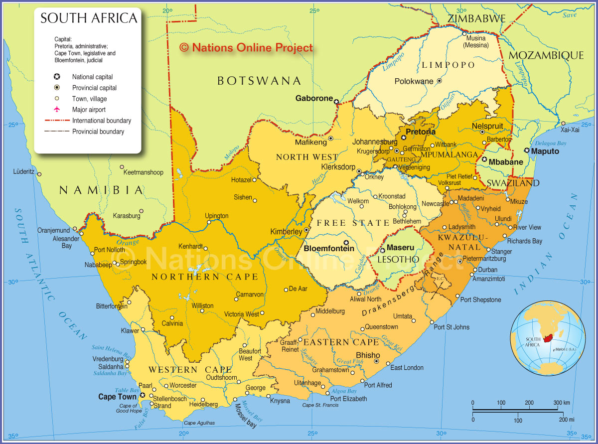
Here is a beautiful map of South Africa. Let's get some basic facts about the nation together:

1. The Republic of South Africa is divided into nine provinces: Eastern Cape, Free State, Gauteng, KwaZulu-Natal, Limpopo, Mpumalanga, North West, Northern Cape and Western Cape

2. While the executive capital is Pretoria, Blomfontein is the judicial capital and Cape Town the legislative.

3. Population is about 52 million (2011 census)

4. The largest cities are Johannesburg and Soweto in Gauteng Province and Cape Town in Western Cape Province, in that order.

Meanwhile, H has been sending me some excellent information about South Africa. Read on:

Wednesday, October 26, 2011

Blue-Green Beauty

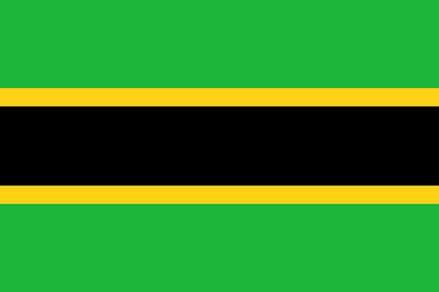
The name Tanzania derives from the names of the two states Tanganyika and Zanzibar that united in 1964 to form the United Republic of Tanganyika and Zanzibar, which later the same year was renamed the United Republic of Tanzania. The Flag of Tanzania was adopted on 30 June 1964. It was a merger of the flags of Tanganyika and Zanzibar.


The Flag of Tanganyika:
The Flag of Zanzibar:
Et Voilà, The Flag of Tanzania:

Saturday, September 3, 2011

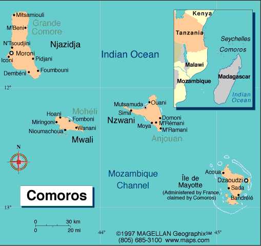
Comoros


At the Africa Inland Mission's Mayfield Guesthouse, we met an American couple on their way to (live and work in) Comoros. We knew nothing about the place, so here we go:

Full name: The Union of the Comoros
Population: 691,400 (UN, 2010)
Capital: Moroni
Area: 1,862 sq km (719 sq miles)
Major languages: Arabic (official), French (official), Comoran/Shikomoro (a blend of Swahili and Arabic)
Major religion: Islam
Life expectancy: 65 years (men), 70 years (women) (UN)
Monetary unit: 1 Comoran franc = 100 centimes
Main exports: Vanilla, cloves, perfume oil, copra
GNI per capita: US $870 (World Bank, 2009)
Internet domain: .km


Geography: The Comoros is formed by Ngazidja (Grande Comore), Mwali (Mohéli), Nzwani (Anjouan), and Maore (Mayotte), the major islands in the Comoros Archipelago, as well as many minor islets. The islands are officially known by their Comorian language names, though international sources still use their French names (given in parentheses above). The capital and largest city, Moroni, is located on Ngazidja. The archipelago is situated in the Indian Ocean, in the Mozambique Channel, between the African coast (nearest to Mozambique and Tanzania) and Madagascar, with no land borders.

Economy: One of the world's poorest countries, Comoros is made up of three islands that have inadequate transportation links, a young and rapidly increasing population, and few natural resources. The low educational level of the labor force contributes to a subsistence level of economic activity, high unemployment, and a heavy dependence on foreign grants and technical assistance. Agriculture, including fishing, hunting, and forestry, contributes 40% to GDP, employs 80% of the labor force, and provides most of the exports. Export income is heavily reliant on the three main crops of vanilla, cloves, and ylang-ylang and Comoros' export earnings are easily disrupted by disasters such as fires. The country is not self-sufficient in food production; rice, the main staple, accounts for the bulk of imports. The government - which is hampered by internal political disputes - lacks a comprehensive strategy to attract foreign investment and is struggling to upgrade education and technical training, privatize commercial and industrial enterprises, improve health services, diversify exports, promote tourism, and reduce the high population growth rate. Political problems have inhibited growth, which has averaged only about 1% in 2006-09. Remittances from 150,000 Comorans abroad help supplement GDP. In September 2009 the IMF approved Comoros for a three-year $21 million loan. The IMF gave generally positive reports of the country's program performance as of October 2010. The African Development Bank approved a $34.6 million debt-relief package loan for Comoros in September 2010, and Comoros will attempt to qualify for debt relief in 2012 under the IMF and World Bank's Heavily Indebted Poor Countries (HIPC) initiative.


Monday, August 22, 2011

Carte d'Afrique

From travelblog.org, a map of Africa on the wall of a Rwandan school, Nyamata.

Monday, January 10, 2011

Burundi

NatGeo Picture: Burundi drummers perform during a tribal ceremony in Ninga.

From the NatGeo Guide:

Small, poor, densely populated, and landlocked, Burundi lies just south of the Equator in central Africa. From the capital, Bujumbura, on Lake Tanganyika, a great escarpment rises to fertile highlands. Agriculture employs 90 percent of the people, with most being subsistence farmers. Since independence in 1962, Burundi has been plagued by ethnic conflict between the majority Hutus and the Tutsis, who tend to dominate the government and army—but are only 14 percent of the population. A 2003 cease-fire and new government offer hope for peace.


I found this information from the World Factbook interesting:
Burundi's first democratically elected president was assassinated in October 1993 after only 100 days in office, triggering widespread ethnic violence between Hutu and Tutsi factions. More than 200,000 Burundians perished during the conflict that spanned almost a dozen years. Hundreds of thousands of Burundians were internally displaced or became refugees in neighboring countries. An internationally brokered power-sharing agreement between the Tutsi-dominated government and the Hutu rebels in 2003 paved the way for a transition process that led to an integrated defense force, established a new constitution in 2005, and elected a majority Hutu government in 2005. The new government, led by President Pierre Nkurunziza, signed a South African brokered ceasefire with the country's last rebel group in September of 2006 but still faces many challenges.
Mini Fact-File:
  • Official Languages: Kirundi, French (and unofficial: Swahili)
  • Independence: From Belgium in 1962
  • Capital: Bujumbura
  • Currency: Burundi franc

Monday, November 1, 2010

The True Size of Africa


Wow! Does this put Africa's true size in perspective or what?

Monday, March 8, 2010

ECOWAS


This acronym puzzled me for months (Echoas, Echoise, Eckowass, I tried them all). Today's a day to say "Aha!". From Wikipedia:
The Economic Community of West African States (ECOWAS) is a regional group of fifteen West African countries, founded on May 28, 1975, with the signing of the Treaty of Lagos. Its mission is to promote economic integration. In 1976 Cape Verde joined ECOWAS, and in December 2000 Mauritania withdrew, having announced its intention to do so in December 1999.
It was founded to achieve "collective self-sufficiency" for the member states by means of economic and monetary union creating a single large trading bloc. The very slow progress towards this aim meant that the treaty was revised in Cotonou on July 24, 1993, towards a looser collaboration. The ECOWAS Secretariat and the Fund for Cooperation, Compensation and Development are its two main institutions to implement policies. The ECOWAS Fund was transformed into the ECOWAS Bank for Investment and Development in 2001. ECOWAS is one of the pillars of the African Economic Community (AEC).
The current President of the Commission is James Victor Gbeho. The current chairman is acting President Goodluck Jonathan of Nigeria.
It operates officially in three coequal languages (English, French, and Portuguese).

Wednesday, August 12, 2009

Languages in Sub-Saharan Africa

Image from here.
Linguistically, sub-Saharan Africa is dominated by the Niger-Congo phylum (distribution shown in yellow), with pockets of Khoi-San in Southern Africa, Nilo-Saharan in Central and East Africa, and Afro-Asiatic in the Horn of Africa. Read more here.

Tuesday, August 11, 2009

Sub-Saharan Africa

We often hear the term "Sub-Saharan Africa". What area does this term refer to?

  • Sub-Saharan Africa is a geographical term used to describe the area of the African continent which lies south of the Sahara, or those African countries which are fully or partially located south of the Sahara.
  • It contrasts with North Africa, which is considered a part of the Arab World.
    The Sahel is the transitional zone between the Sahara and the tropical savanna (the Sudan region) and forest-savanna mosaic to the south.
  • The Horn of Africa and large parts of Sudan are geographically part of sub-Saharan Africa, but nevertheless show strong Middle Eastern influence and are also part of the Arab world.
  • The Sub-Saharan region is also known as Black Africa, in reference to its many black populations.
Simplified climatic map of Africa: Sub-Saharan Africa consists of the arid Sahel and the Horn of Africa in the north (yellow), the tropical savannas (light green) and the tropical rainforests (dark green) of Equatorial Africa, and the arid Kalahari Basin (yellow) and the "Mediterranean" south coast (olive) of Southern Africa. The numbers shown correspond to the dates of iron artifacts associated with the Bantu expansion.

Tuesday, April 7, 2009

Francophone Africa

Map highlighting Francophone Africa

██ Pays normalement considérés francophones / Countries usually considered as Francophone Africa

██ Pays parfois considérés francophones / Countries sometimes considered as Francophone Africa


This map from Wikipedia indicates the countries in Africa in which French is spoken. If you're a French-speaking traveller, Africa is obviously a great continent to visit!

From the Wiki page on African French, French is spoken by an estimated 115 million African people spread across 31 francophone African countries.

Tuesday, March 31, 2009

Map of Africa

I must have looked through a few hundred maps of Africa. This one from Safari Now is my absolute favourite. I love the colors and the fonts.

Click on the picture to see it in full size.

Wednesday, March 25, 2009

Landlocked!


Of all the 44(!) landlocked countries in the world, many of which are located in Africa, I am most fascinated by Lesotho which is completely landlocked by one nation! Only San Marino and Vatican City share this rare geographic feature. What it must feel like to cross the border in any direction and end up in South Africa, I wonder!

Lesotho also has the distinction of being the only independent state in the world that lies entirely above 1,000 metres (3,300 ft) in elevation. The national language, Sesotho seems very similar to Botswana's Setswana, both of them being Bantu languages (learn more). Sesotho also seems to follow the practice of adding prefixes to a common root to form new words.

Monday, March 23, 2009

African Continent

African Continent by BenHeine

What a brilliant idea! Bravo! I found this beautiful drawing here. (Larger and better version here).

African elephants are the species of elephants in the genus Loxodonta. That sounds a lot like 'Ekadanta' (one who has one tusk), one of the many names of the Indian Elephant God, Ganesha.

And speaking of elephants, did you hear about the adorable baby Pink Elephant they found in Botswana's Okavango delta?

Wednesday, March 18, 2009

Africa Today

I subscribed very recently to the BBC’s Africa Today Podcast (other radio programs with a focus on Africa can be found here). The program lasts about 15 minutes and hence is a rather convenient option to catch up with Africa’s current events on a daily basis. The program features the latest news and analyses from Africa, including regular interviews with public figures and local voices and updates from journalists all over the continent. In addition, they have special features such as the one last week, in which they asked a few African entrepreneurs to give the listeners some tips on running a successfull business. I found these tips insightful and pictured Mma Ramotswe giving her views as well (all of them mentioned 'hard work' and I can bet Mma would've too!). I enjoy the program for one more reason - it gives me great pleasure to begin my drive to work with rhythmic African drums and a multitude of beautiful African accents dancing in my ears.