Showing posts with label Geography. Show all posts

Saturday, March 16, 2013

Hartbeespoort

This morning, we woke up very early and drove to Hartbeespoort, informally known as "Harties", a small resort town in the North West Province of South Africa, situated on the slopes of the Magaliesberg mountain range and the banks of the Hartbeespoort Dam. The name of the town means "pass of the hartbees" (a species of antelope) in Afrikaans. It was previously known as Schoemansville, named after General Hendrik Schoeman (1840 - 1901), a Boer General in the Anglo-Boer War who owned the farm that the dam was built on. The dam was originally designed for irrigation which is currently its primary use. It is fed by the waters of the Crocodile and Magalies rivers.
Picture from intotravel.co.za
So, why did we wake up so early? To make it in time for Om Die Dam ('Around the dam'), the annual 50k ultra marathon (they also have a half-marathon and a 5k). The sun hid behind the clouds and granted us some beautiful running weather. The 5k path led us through quiet, hilly residential streets with beautiful homes (most with barking dogs, who seemed ready for the annual onslaught of morning pedestrians).

After the run, we walked to the Hartbeespoort Aerial Cableway (apparently the longest monocableway in Africa) and took a ride to the top for a spectacular panorama of the town, the calm waters and the endless mountains.

Saturday, February 9, 2013

RSA Factfile

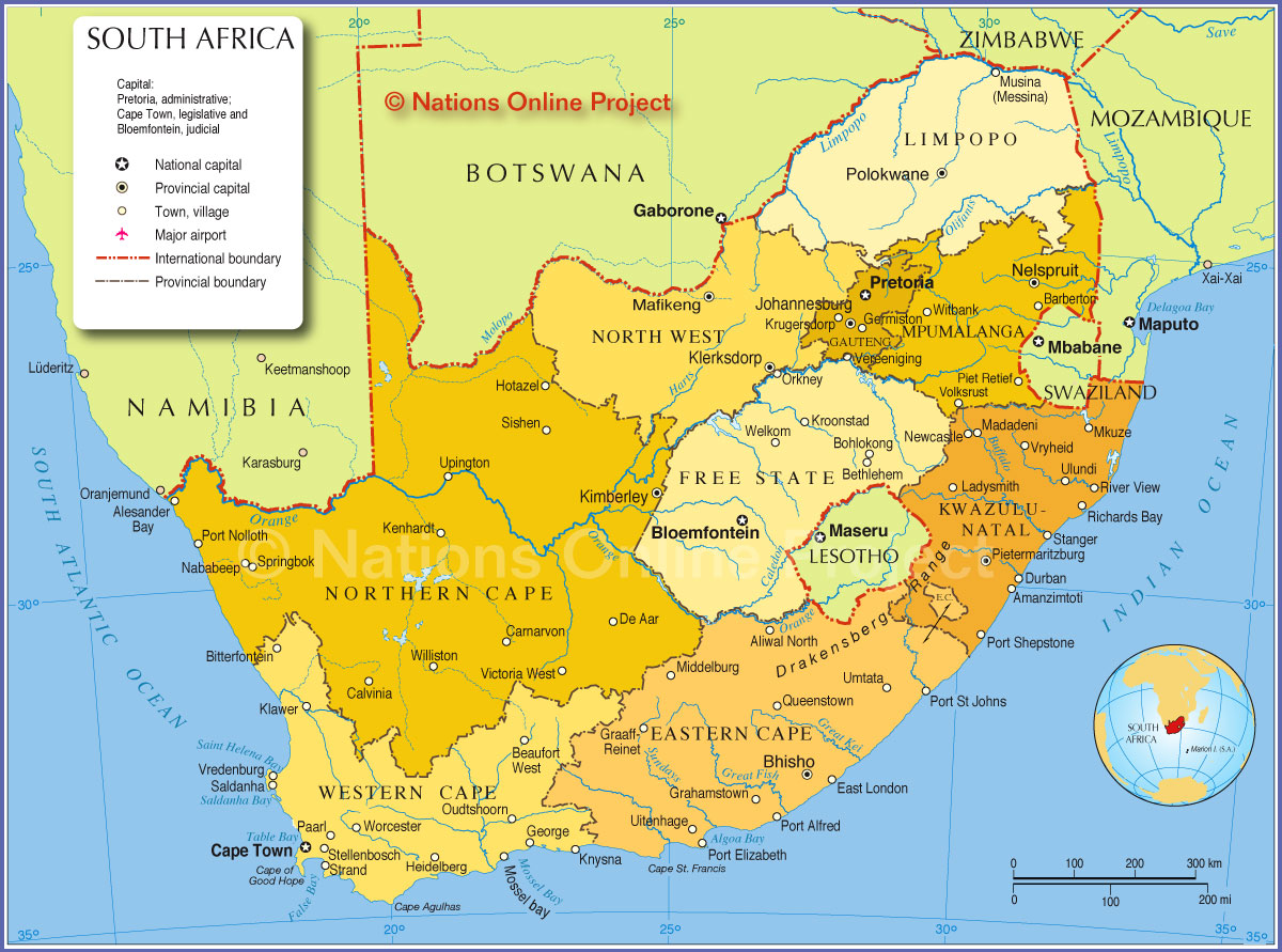
Here is a beautiful map of South Africa. Let's get some basic facts about the nation together:

1. The Republic of South Africa is divided into nine provinces: Eastern Cape, Free State, Gauteng, KwaZulu-Natal, Limpopo, Mpumalanga, North West, Northern Cape and Western Cape

2. While the executive capital is Pretoria, Blomfontein is the judicial capital and Cape Town the legislative.

3. Population is about 52 million (2011 census)

4. The largest cities are Johannesburg and Soweto in Gauteng Province and Cape Town in Western Cape Province, in that order.

Meanwhile, H has been sending me some excellent information about South Africa. Read on:

Wednesday, February 17, 2010

Out of Africa - II

After hearing innumerable references to the film, I finally watched 'Out of Africa'. The film, which is based on a true story, and adapted from the writings of Karen Blixen, showcases various aspects of Kenya, notably:

I enjoyed the film very much (except the hunting scenes) and found it romantic and touching.

The film on Wiki, and the book it was based on.

Monday, November 2, 2009

African Desert Rift Confirmed As New Ocean In The Making

I was sent (Thanks, R), this interesting article about a 35-mile-long rift that broke open the desert ground in Ethiopia.


Picture from rochester.edu article on the same topic.

"In 2005, a gigantic, 35-mile-long rift broke open the desert ground in Ethiopia. At the time, some geologists believed the rift was the beginning of a new ocean as two parts of the African continent pulled apart, but the claim was controversial.

Now, scientists from several countries have confirmed that the volcanic processes at work beneath the Ethiopian rift are nearly identical to those at the bottom of the world's oceans, and the rift is indeed likely the beginning of a new sea."

Tuesday, August 11, 2009

Sub-Saharan Africa

We often hear the term "Sub-Saharan Africa". What area does this term refer to?

  • Sub-Saharan Africa is a geographical term used to describe the area of the African continent which lies south of the Sahara, or those African countries which are fully or partially located south of the Sahara.
  • It contrasts with North Africa, which is considered a part of the Arab World.
    The Sahel is the transitional zone between the Sahara and the tropical savanna (the Sudan region) and forest-savanna mosaic to the south.
  • The Horn of Africa and large parts of Sudan are geographically part of sub-Saharan Africa, but nevertheless show strong Middle Eastern influence and are also part of the Arab world.
  • The Sub-Saharan region is also known as Black Africa, in reference to its many black populations.
Simplified climatic map of Africa: Sub-Saharan Africa consists of the arid Sahel and the Horn of Africa in the north (yellow), the tropical savannas (light green) and the tropical rainforests (dark green) of Equatorial Africa, and the arid Kalahari Basin (yellow) and the "Mediterranean" south coast (olive) of Southern Africa. The numbers shown correspond to the dates of iron artifacts associated with the Bantu expansion.

Monday, August 10, 2009

The Sahara Desert


  • The Sahara ("The Greatest Desert") is the world's largest hot desert.
  • At over 9,000,000 square kilometers (3,500,000 sq mi), it covers most of Northern Africa, making it almost as large as the United States or the continent of Europe.
  • The desert stretches from the Red Sea, including parts of the Mediterranean coasts, to the outskirts of the Atlantic Ocean.
  • The Sahara divides the continent of Africa into North and Sub-Saharan Africa.
  • To the south, it is delimited by the Sahel: a belt of semi-arid tropical savanna that comprises the northern region of central and western Sub-Saharan Africa.
  • The Sahara covers huge parts of Algeria, Chad, Egypt, Libya, Mali, Mauritania, Morocco, Niger, Western Sahara, Sudan and Tunisia.
  • Read more here.

Tuesday, March 31, 2009

Map of Africa

I must have looked through a few hundred maps of Africa. This one from Safari Now is my absolute favourite. I love the colors and the fonts.

Click on the picture to see it in full size.

Wednesday, March 25, 2009

Landlocked!


Of all the 44(!) landlocked countries in the world, many of which are located in Africa, I am most fascinated by Lesotho which is completely landlocked by one nation! Only San Marino and Vatican City share this rare geographic feature. What it must feel like to cross the border in any direction and end up in South Africa, I wonder!

Lesotho also has the distinction of being the only independent state in the world that lies entirely above 1,000 metres (3,300 ft) in elevation. The national language, Sesotho seems very similar to Botswana's Setswana, both of them being Bantu languages (learn more). Sesotho also seems to follow the practice of adding prefixes to a common root to form new words.

Monday, March 23, 2009

African Continent

African Continent by BenHeine

What a brilliant idea! Bravo! I found this beautiful drawing here. (Larger and better version here).

African elephants are the species of elephants in the genus Loxodonta. That sounds a lot like 'Ekadanta' (one who has one tusk), one of the many names of the Indian Elephant God, Ganesha.

And speaking of elephants, did you hear about the adorable baby Pink Elephant they found in Botswana's Okavango delta?